

Navigating Flood Risk and SuDS in 2026: A Definitive Guide for Developers
The rules around flood risk in England have changed dramatically. Between the December 2023/24 NPPF updates, a landmark Court of Appeal ruling in 2024 (Mead Realisations), and the September 2025 Planning Practice Guidance revisions, flood risk has gone from being a box-ticking exercise to a make-or-break planning constraint.
If you're developing in 2026, you need to understand the Sequential Test and the new SuDS requirements inside out. Get these wrong and you'll face refusals, expensive redesigns, and months of delays. Get them right and you'll have a competitive advantage over developers still working from outdated playbooks.
The Sequential Test: New Scope and Pragmatic Solutions
The Sequential Test is the gatekeeper of flood risk planning. Its job is simple: steer development toward Flood Zone 1, the areas with lowest flood risk. But what triggers this test has expanded significantly, whilst new policies have opened practical escape routes for constrained sites.
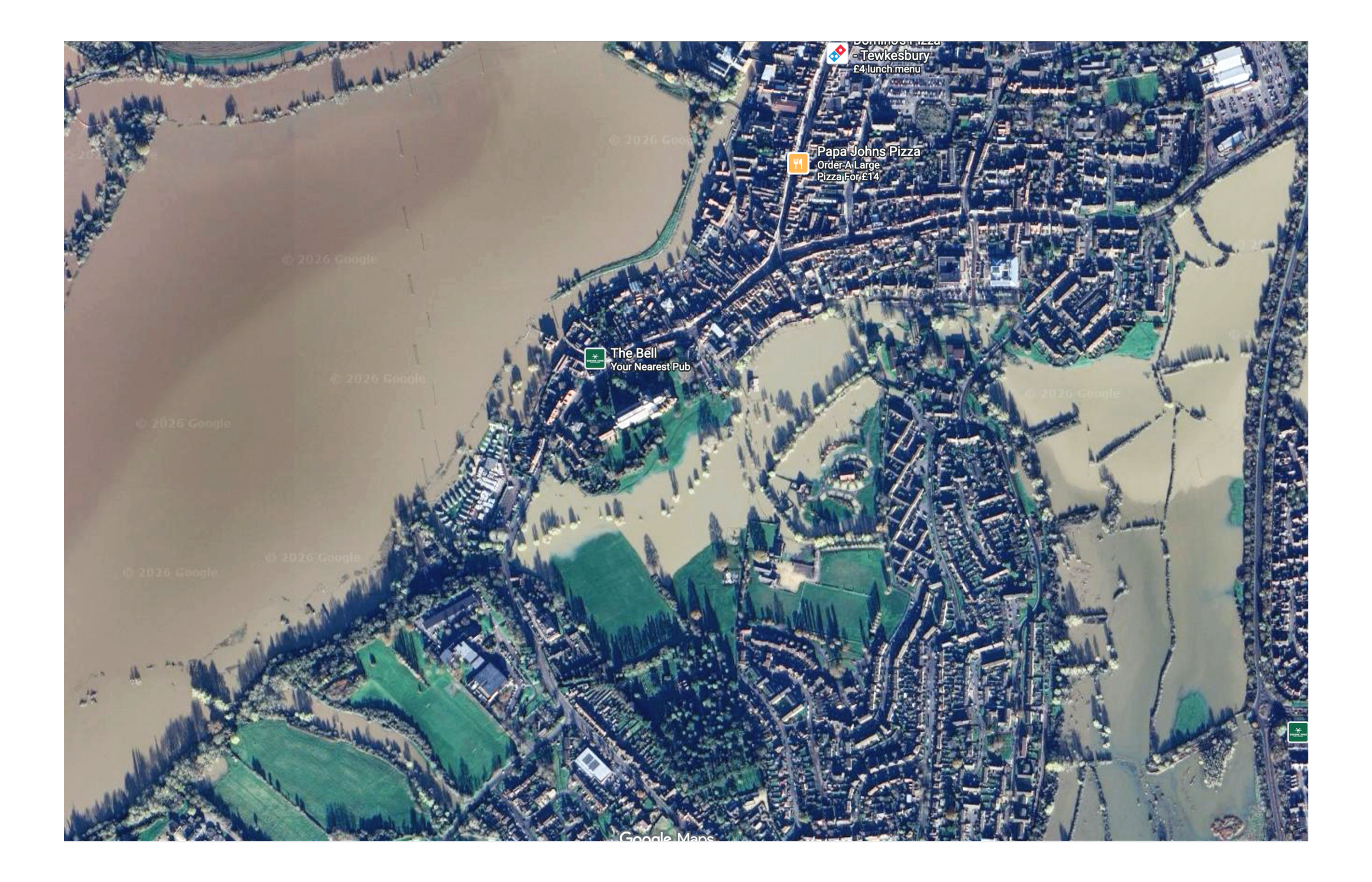
source - Google Maps
All Sources of Flooding Now Trigger the Test
Here's where many developers trip up: they think the Sequential Test only applies to river and sea flooding. It doesn't. NPPF Paragraph 167 and the Mead Realisations ruling have made it crystal clear—the Sequential Test applies to all sources of flood risk.
That means surface water flooding (when drains overflow), groundwater flooding (when water tables rise), even sewer flooding and reservoir risk. Your site might be in Flood Zone 1 on the standard maps, but if Environment Agency surface water mapping shows any flood risk, you're potentially in Sequential Test territory.
The 2026 reality: You can't rely on a quick desktop check of flood zones anymore. At the site acquisition stage, you need to review the Environment Agency's Risk of Flooding from Surface Water maps. Miss this step and you might buy a site that looks developable but triggers Sequential Test requirements you didn't budget for.
The "Avoidance" Strategy: NPPF Paragraph 169
Here's the good news. NPPF Paragraph 169 gives you a practical way to sidestep the Sequential Test on partially affected sites. If your site-specific Flood Risk Assessment can demonstrate that all built development—houses, access roads, private gardens—sits entirely within the low-risk areas, you don't need to run a Sequential Test at all.
The trick is using the flood-affected portions of your site for "water-compatible" uses. Public open space works perfectly. So do biodiversity net gain areas, SuDS features, and landscaping. Design your masterplan to keep buildings out of flood zones, and you can often avoid the Sequential Test headache entirely.
Pro tip: This is a masterplanning exercise, not an afterthought. Configure your layout from day one with flood avoidance in mind, and you'll save yourself enormous hassle down the line.
Defining the "Area of Search" (Sept 2025 PPG Update)
One of the biggest sources of frustration with the Sequential Test has always been the question: how far do we need to look for alternative sites? Do you compare against every site in the entire housing market area? Just neighbouring towns?
The September 2025 PPG update finally provided clear answers in Paragraph 27a. The "area of search" now depends on the functional requirements of your development:
Housing: Typically the Local Authority area, though not necessarily the entire housing market area if that extends beyond the authority boundary
Catchment-specific uses: For schools, local shops, community facilities, you can narrow the search to the specific community catchment the development is designed to serve
This is a big improvement. It stops planning officers demanding you compare your site against alternatives 50 miles away that clearly wouldn't serve the same function.
2026 Climate Change Allowances: Designing for 2070 and Beyond
Your Flood Risk Assessment needs to prove your development will remain safe not just today, but throughout its lifetime. For residential development, that typically means proving resilience against climate change through to the 2070s.
Peak Rainfall: The 40–45% Standard
When you're designing drainage, you need to work with the Environment Agency's climate change allowances. In 2026, that means using the "Upper End" allowance for the 2070s epoch.
In practical terms, you're applying a 40% to 45% uplift to peak rainfall intensity. So your drainage system doesn't just need to handle today's 1-in-100-year storm—it needs to contain that same storm plus 45% more rainfall intensity, all without flooding buildings or pushing excess water onto neighbouring properties.
This isn't optional. Planning officers and Lead Local Flood Authorities will scrutinise your climate change assumptions. Use lower allowances to make your drainage calculations look better, and you'll get sent straight back to redesign with proper allowances applied.
Peak River Flows
If your site is near a watercourse, you'll also need to apply climate change allowances to river flows. The "Higher Central" or "Upper End" allowances typically translate to a 25% to 35% uplift for residential schemes, depending on which Environment Agency management catchment you're in.
Again, this affects your Flood Risk Assessment and site layout. Flood zones expand when you factor in climate change. Land that looks safe today might be at risk by 2070, and your FRA needs to account for that.
Practical Implications for Site Assessment
For developers, early-stage site assessment must now include comprehensive surface water flood risk review. Environment Agency Risk of Flooding from Surface Water mapping provides initial screening, showing surface water flood risk in 1-in-30-year, 1-in-100-year, and 1-in-1000-year events.
If mapping shows any surface water flooding on or adjacent to your site, three options exist. First, configure development to avoid all surface water flood risk areas entirely, demonstrating through FRA that development will be safe throughout its lifetime without increasing risk elsewhere. Second, undertake Sequential Test demonstrating no reasonably available lower-risk alternatives exist. Third, commission detailed surface water modelling proving the site-specific exception applies.
The choice depends on site characteristics, alternative site availability, and development economics. For constrained sites where Sequential Tests would be difficult to pass, investing in detailed hydraulic modelling to prove the surface water exception may be more viable than abandoning the site.
The New SuDS Mandate: Proportionality for All
The December 2023/24 NPPF ended the era where developers could duck SuDS requirements by designing schemes just under the "major development" threshold. Under Paragraph 173, SuDS are now required for all applications that could affect drainage—scaled appropriately to the size of the development.
The "Minor Development" Checklist
Even if you're building a single house or a small extension, you need to think about sustainable drainage. The 2026 standard follows what's called the "SuDS Management Train":
Source Control: This is your first line of defence. Water butts and rainwater harvesting are now baseline requirements, not nice-to-haves.
Permeable Surfaces: Any new driveways, parking areas, or hardstanding needs to be permeable. Block paving with open joints, gravel, reinforced grass—there are plenty of options, but standard impermeable tarmac won't cut it anymore.
Nature-Based Solutions: Planning officers in 2026 strongly favour "blue-green" infrastructure. Rain gardens, swales, planted depressions—these multifunctional features that manage water whilst providing biodiversity and amenity benefits. They're much more likely to gain approval than purely engineered solutions like underground plastic attenuation tanks.
The key word is proportionate. A small extension doesn't need a complex attenuation system. But it does need to demonstrate some level of sustainable drainage thinking, even if that's just water butts and permeable paving
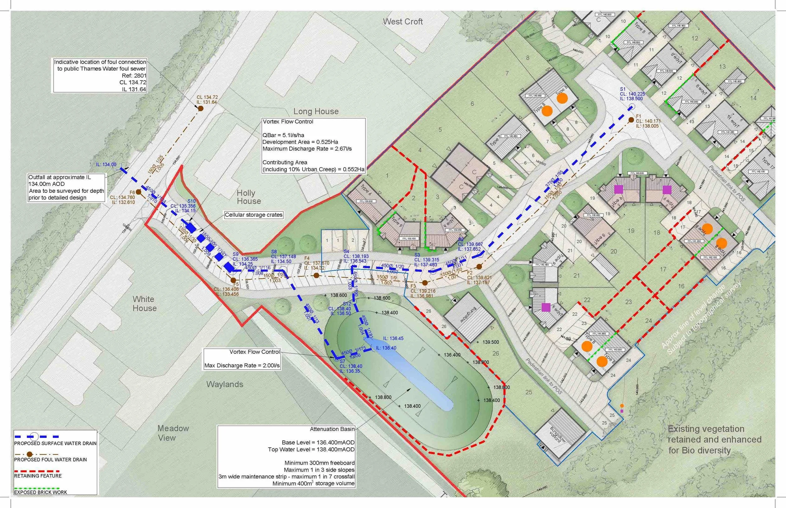
The Lead Local Flood Authority (LLFA) Role
For major developments, the LLFA acts as statutory consultee and apply local standards and policies against national guidance. In 2026, they're not just checking your runoff calculations—e.g. requiring runoff rates to match greenfield rates (typically 1-5 litres per second per hectare), and potentially permitting higher rates with justification - they're scrutinising whether your SuDS scheme delivers multifunctional benefits.
A drainage strategy that only manages water quantity isn't enough anymore. Your scheme needs to demonstrate improvements in water quality (through pollution removal), biodiversity (through vegetation and habitat creation), and amenity (through attractive water features that enhance the public realm).
Early engagement with the LLFA is essential for major development. Pre-application discussions (typically costing £500-2,000 depending on authority and scheme complexity) allow an understanding of LLFA expectations, agreeing runoff rates and discharge points, and identifying any specific local requirements before detailed design. Submitting drainage strategies without LLFA input risks objections and redesign requirements.
Find out what your local LLFA prioritises, agree on runoff rates and SuDS components upfront, and you'll avoid the back-and-forth that causes delays during determination.
Practical Implementation: Avoiding Common Pitfalls
Getting flood risk and SuDS right in 2026 comes down to tackling it at the right stages of your development process. Here's the five-stage approach that works:
Stage 1: Site Acquisition and Feasibility
Screen for surface water and groundwater risk during your initial site due diligence, not after you've exchanged. If flood risk is present, you need to factor in the "lost" developable land you'll need for SuDS and flood avoidance.
This affects your land valuation and development economics. Better to know upfront than discover mid-design that you've lost 20% of your developable area to flood zones and attenuation basins.
Stage 2: Masterplanning and Layout
Use NPPF Paragraph 169 to "design out" the Sequential Test requirement by placing all your built footprints in the lowest-risk areas. This isn't about squeezing development into unsuitable areas—it's about smart site layout that concentrates buildings on the safe ground whilst using flood-prone areas for open space and environmental features.
This approach often results in better developments. The flood zones become your green infrastructure spine, with buildings arranged around them rather than crammed onto every square metre of the site.
Stage 3: Pre-App Engagement
For major schemes, engage the LLFA early—ideally before you finalise your drainage design. Agree on runoff rates, confirm they're happy with your climate change uplifts (that 45% peak rainfall allowance), and get their input on SuDS components before you submit your full drainage strategy.
Yes, pre-app advice costs money (as mentioned, typically £500-£2,000 depending on the authority and scheme complexity). But it's a fraction of what you'll spend if you get an LLFA objection post-submission and have to redesign your entire drainage strategy.
Stage 4: Robust Flood Risk Assessment (FRA)
Your Flood Risk Assessment needs two elements that planning officers increasingly scrutinise:
Maintenance plan: Who's maintaining the SuDS? How? What happens if maintenance lapses? Generic "management company will maintain" statements won't suffice—you need specifics on inspection frequency, maintenance tasks, and funding mechanisms.
Exceedance flow map: What happens when your drainage system is overwhelmed? Where does the water go? Your FRA needs to show exceedance flow routes that direct water safely away from buildings, even in storms that exceed your design capacity.
These aren't optional extras—they're core requirements for approval in 2026.
Stage 5: The Planning Statement
Planning statements must explicitly address NPPF flood risk policy and demonstrate compliance. Specifically:
Confirm which flood sources affect the site and their probability
Explain whether Sequential Test applies or whether layout-based exception is met
Reference LLFA pre-application advice for major development
Demonstrate SuDS provision proportionate to development scale
Confirm climate change allowances applied in FRA
Address local authority flood risk policies (often stricter than national policy)
Don't assume planning officers will infer compliance from a submitted FRA. Explicitly state how the development complies with current policy and guidance to avoid requests for further information or refusals for policy non-compliance.
Conclusion
The 2026 flood risk policy environment rewards developers who treat water as a design opportunity rather than a compliance burden. By integrating flood avoidance and nature-based drainage into your initial site layout, you satisfy the stringent Sequential Test and SuDS requirements whilst delivering more sustainable, attractive developments that planning officers actually want to approve.
The developers who struggle in 2026 are those still working from the old playbook—treating flood risk as something to be "mitigated away" after the layout's been fixed, or assuming surface water flooding doesn't matter because the site's in Flood Zone 1.
The developers who succeed understand that flood risk planning has fundamentally changed. They screen for all flood sources at acquisition, masterplan around constraints rather than fighting them, engage specialists early, and design SuDS that deliver multiple benefits.
If you need technical coordination for Flood Risk Assessments, drainage strategies, or Sequential Test evidence supporting planning applications, contact Sovatech Consulting. We'll coordinate the technical specialists and evidence demonstrating flood risk policy compliance—helping you navigate Sequential Test requirements, surface water flooding constraints, and SuDS obligations efficiently.